Thinking about splitting acreage near Lake Oconee? Subdividing can unlock value, but the process has moving parts that change by parcel and jurisdiction. You want a clear path, realistic timelines, and the right team from day one. This guide breaks down how subdivision works in Eatonton and Putnam County so you can plan with confidence. Let’s dive in.
Start with feasibility checks
Before you sketch lot lines, confirm that your property can be split and built the way you expect. A few early checks will help you avoid dead ends and save time.
Review deeds and covenants
Pull your deed and any recorded plats to look for easements, rights-of-way, and restrictive covenants that limit further subdivision. Pay attention to any lake-related covenants that control shoreline use, docks, or access. If you find complex title items or unclear language, a land use attorney can help interpret and draft any new easements you may need.
Confirm jurisdiction and zoning
Determine whether your land sits in the City of Eatonton or unincorporated Putnam County. The subdivision rules, application process, and fees differ. Check your zoning district, minimum lot size, frontage requirements, and setbacks. The local planning office is the authoritative source for submittal checklists, timelines, and the difference between administrative and full subdivision review.
Check utilities and access
Find out if municipal water or sewer is available at your frontage. If sewer is not available, plan for septic on each lot and a site/soil evaluation through Environmental Health. Confirm that each lot will have legal access from a public road or a recorded private easement that meets local standards.
Map floodplain and wetlands
Review FEMA flood maps to identify any flood hazard areas on your tract. If wetlands or low-lying areas are present, expect more study. Work in wetlands or waters may fall under U.S. Army Corps of Engineers jurisdiction and can require permits that add time.
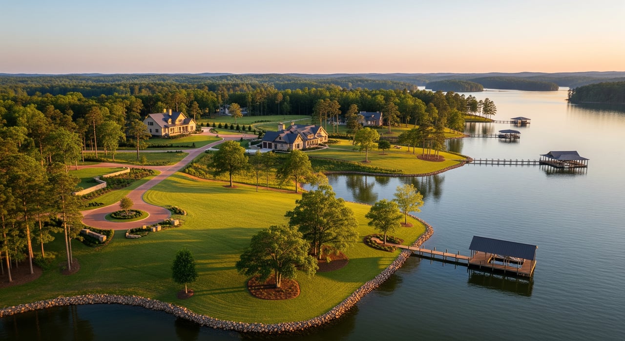
Respect lake buffers and shoreline
Lake Oconee parcels often have buffer and setback rules that protect water quality. These reduce buildable area and affect where septic drainfields, driveways, and homes can go. Shoreline uses like docks or riprap may also require approval from the lake shoreline authority.
Build your local team
Engage key professionals early. On most projects you will want:
- A licensed land surveyor for boundary and topographic surveys, deed research, and final plat preparation.
- A civil or site engineer to plan lot layout, access, grading, and stormwater/erosion control.
- An environmental consultant for wetland delineation if you have low-lying or lakeshore areas.
- A septic designer or soil scientist for site evaluations and system design when sewer is not available.
- An attorney for title issues, easements, covenants, HOA documents, and complex approvals.
Early coordination helps you avoid rework and align your concept with local standards.
Create a concept plan
Ask your surveyor and engineer to draft a conceptual layout that shows tentative lot lines, access, setbacks, building envelopes, wetlands, floodplain, and proposed septic or utility locations. Then request a pre-application or concept meeting with planning staff. This step clarifies whether your plan qualifies for an administrative split or will require a full subdivision review and any public hearing.
Minor split vs major subdivision
Your path depends on scope and complexity.
- Minor split: A small number of lots or a boundary adjustment that meets zoning, frontage, and access standards. These are often handled through administrative review with a metes-and-bounds description or minor plat. Timelines are shorter and engineering is limited.
- Major subdivision: Multiple lots with new roads or infrastructure. This route requires preliminary plat approval, engineered construction plans for roads and stormwater, and possibly bonding or a development agreement. Public notice or hearings may be required.
The local subdivision ordinance defines the exact triggers. Planning staff can confirm how your plan will be classified and what to submit.
Permits and technical rules
Subdivision near the lake brings extra attention to water, soil, and drainage. Plan for the following requirements.
Stormwater and erosion control
Most projects need an erosion and sediment control plan. If you disturb more than 1 acre of soil, you will typically need a construction stormwater permit, along with notices and inspections. Expect to install best practices like silt fencing and stabilized construction entrances to protect the lake.
Septic and water supply
If public sewer is not available, each lot will need a site and soil evaluation and an individual septic permit through Environmental Health. Lake-adjacent slopes, buffers, and setbacks can affect where systems fit. Water may come from a municipal provider or a private well depending on location and availability.
Roads and access standards
New public roads must be built to city or county standards and formally accepted. Private roads may be allowed if they meet minimum construction standards and include a recorded maintenance agreement or HOA. Either way, ensure every lot has legal, compliant access.
Wetlands and stream buffers
Wetlands and waters often occur along Lake Oconee’s edges. Impacts to these areas can require federal and state permits, which add time and may require mitigation. Designing around wetlands often preserves schedule and reduces cost.
Floodplain requirements
If building in a mapped floodplain, expect elevation and construction standards that protect structures from flood risk. Your engineer and surveyor can show floodplain limits on your plat and plan compliant building pads.
Shoreline considerations
Shoreline modifications, docks, and related work may require separate shoreline approvals. Coordinate early so your lot layout and access align with shoreline rules and buffer requirements.
Timelines and soft costs
Budgets and timelines vary by parcel size, lot count, terrain, and environmental limits. The ranges below are common for Georgia and the Southeast. Always obtain local quotes.
- Preliminary feasibility and title research: 1 to 4 weeks; legal/title report typically $300 to $1,000.
- Boundary survey: about $800 to $3,000 for typical rural tracts; ALTA/NSPS surveys can run $1,500 to $6,000 or more.
- Topographic survey: roughly $1,000 to $5,000 or more, depending on acreage and terrain.
- Soil and perc tests: about $300 to $1,500 per location; septic design often $1,000 to $5,000.
- Wetland delineation: commonly $1,500 to $6,000 or more based on size and complexity.
- Civil engineering and site plans: small projects may run $5,000 to $20,000; larger or complex sites can reach $20,000 to $100,000 or more.
- Erosion and stormwater permitting: consultant time roughly $500 to $5,000, plus any state fees.
- Planning submittal and plat prep: about $1,000 to $10,000 depending on complexity and legal work.
- Legal review and covenants: often $1,000 to $10,000.
- County or city review fees: typically $200 to $3,000 or more.
- Road and utility construction: highly variable, often $50,000 to $500,000 or more based on road length, paving, drainage, and extensions.
- Bonds or letters of credit: usually tied to the engineer’s estimate of remaining work.
Typical total timelines from feasibility to a recorded plat:
- Simple split with no new roads and individual septic: about 1 to 3 months if no environmental flags and administrative approval is allowed.
- Minor subdivision with a few lots and moderate site work: roughly 3 to 9 months.
- Major subdivision with new roads and potential wetlands or floodplain permits: about 6 to 18 months or longer, depending on agency reviews.
Construction and final plat
If new roads, drainage, or utilities are required, you will build improvements under the approved engineering plans. Expect inspections during construction. If work is incomplete but acceptable for bonding, a letter of credit or bond may allow final plat approval.
When construction is complete, submit the final plat with required certificates from your surveyor and engineer. After local approval, record the plat with the County Clerk. The Tax Assessor will issue new parcel IDs and update assessments. If you have private roads or common areas, record maintenance agreements or HOA documents so responsibilities are clear.
Avoid common pitfalls
- Skipping early title and covenant review can stall your project later. Clear easements and restrictions up front.
- Ignoring utilities and septic feasibility can shrink or restructure your lot count midstream.
- Underestimating stormwater, buffers, wetlands, and floodplain can trigger redesigns and permits that extend your schedule.
- Designing roads without confirming public versus private standards can lead to costly rebuilds.
- Selling lots before final plat recordation can create legal and financing issues. Record first, then market and close.
Partner with Ashley Goodroe
Subdivision is part planning, part engineering, and part local process. You can reduce risk by pairing expert advisors with a market-savvy land broker who understands East Georgia’s Lake Country and the entitlement path.
Ashley Goodroe brings deep land advisory and commercial brokerage experience across Eatonton and Putnam County. With advanced land credentials and local relationships, Ashley helps you evaluate feasibility, assemble the right team, position lots for the market, and move from concept to executed sales with confidence. When you are ready to talk strategy, valuation, or timing, reach out to discuss your goals and next steps.
Ready to plan your subdivision near Lake Oconee? Connect with Ashley Goodroe for local land advisory and a clear path to market.
FAQs
What is the first step to subdivide near Lake Oconee?
- Start with feasibility: review deeds and covenants, confirm city or county jurisdiction, check zoning and frontage, evaluate utilities and septic, and map floodplain and wetlands.
How do I know if my plan is a minor split or a major subdivision?
- The local subdivision ordinance defines thresholds, but minor splits usually involve a small number of lots with no new roads, while major subdivisions add roads or infrastructure and need engineered plans and formal approvals.
Can I create lots without public sewer in Putnam County?
- Yes, but each lot will need a site and soil evaluation and an individual septic permit through Environmental Health, and setbacks and slopes near the lake can affect system locations.
What permits apply if I disturb more than one acre of soil?
- You will typically need a construction stormwater permit, an approved erosion and sediment control plan, and ongoing inspections during land-disturbing activity.
What if my parcel has wetlands or sits in a floodplain?
- Wetland impacts may require federal and state permits and can add months, while floodplain areas trigger elevation and construction standards that shape where you can build.
Do I need new roads, and who maintains them?
- It depends on access and layout; public roads must meet city or county standards for acceptance, while private roads require minimum standards and a recorded maintenance agreement or HOA.
When can I sell the new lots?
- After your final plat is approved and recorded by the County Clerk; buyers and lenders rely on recorded parcel boundaries and new tax parcel IDs from the Assessor.